It has been some time since the GPS and BeiDou signal anomaly incident in Nanjing. While the cause of the incident remains debated, an interesting question has been frequently discussed in the 'Malagis' GIS group recently: If one day, both our GPS and BeiDou signals are abnormal, and we don't have access to military-grade bands, how can we determine our location? The author has previously written a bit on this topic. Drawing from the group members' discussions and collected materials, here is a summary. Corrections are welcome if any inaccuracies are found.

Before delving into this topic, let's introduce a new concept: All-source Positioning. In this era of the Internet of Everything, the heavily relied-upon GPS is not omnipotent. Satellite signals cannot penetrate thick reinforced concrete or travel underwater. All-source positioning involves integrating various other sensors to provide alternative solutions when GPS fails. So, what are the current common solutions? Let's explore them.
Switch to Another GNSS System
This is the simplest approach. As of 2025, there are many satellite positioning systems orbiting the Earth. If GPS fails, switch to BeiDou; if BeiDou fails, switch to GLONASS (Russia); if GLONASS is unavailable, there's Galileo (European Union); if that's gone, try QZSS (Japan's regional system); and if QZSS is down, IRNSS (India's regional system) is an option.
Do some of these systems sound unfamiliar? That's perfectly normal. In reality, GPS has always been the most well-known global satellite positioning system. However, countries and regions worldwide have recognized the risks of over-reliance on U.S. technology and have subsequently launched their own global or regional navigation systems. But does having these systems mean they are all usable? Not necessarily. It also depends on which navigation systems your phone supports. For instance, Apple iPhones from the iPhone 12 onward generally cover major global GNSS systems like GPS, GLONASS, Galileo, BeiDou, and even QZSS. For other phone models, you need to check their specifications yourself, as supporting an additional positioning system requires corresponding sensors and algorithms in the compact device.
4G/5G Signal Positioning
This method is also a common topic. The author introduced this technology in a previous article "Can Your Mobile Phone Number Really Be Used to Locate You?". Its core principle is trilateration, as shown in the diagram below:
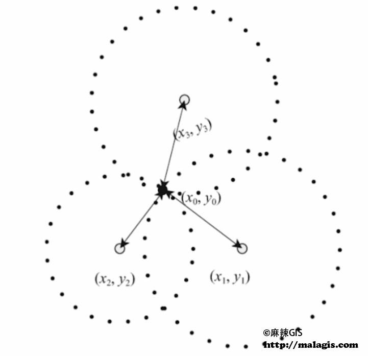
Of course, three points aren't strictly necessary; more points lead to greater accuracy. Considering the ubiquitous cell towers in our daily lives, unless you're in a very remote area, positioning via this method is generally possible. This is also one of the technical principles behind tracking a suspect's location after a phone call on TV dramas. Of course, with widespread public knowledge nowadays, even novice thieves know to turn off their phones and remove SIM cards.
Visual Positioning
This is quite fascinating. In a previous article "Sharing Three Directions for Combining AI (Nano Banana) with GIS Applications", the author introduced a remarkable AI application: estimating the location where a photo was taken based on the image itself.

Visual positioning technology is one of the fastest-developing positioning technologies in recent years. It utilizes computer vision and artificial intelligence to determine location by analyzing images captured by cameras. Visual SLAM (Simultaneous Localization and Mapping) systems take continuously captured image frames as input and output the camera's motion trajectory in space and a reconstruction of the 3D geometric structure of the environment. The advantage of visual positioning lies in its high precision and rich information. It not only determines location but also provides semantic information about the environment, even applicable to indoor navigation scenarios. However, its accuracy is limited by pre-collected data and factors like lighting changes and occlusion. Currently, the author remains optimistic about this technology, believing it could become a mainstream positioning solution in the near future.
Geomagnetic Positioning
Geomagnetic positioning technology leverages the local characteristics of the Earth's magnetic field for positioning, a method that requires no hardware deployment. Earth's magnetic field exhibits subtle variations at different locations, and steel structures within buildings further alter the distribution of the magnetic field, creating a unique magnetic "fingerprint" for each area. The principle involves using the three-axis magnetometer sensor found in smartphones and tablets to detect the three-axis magnetic induction intensity values (X, Y, Z) in an indoor area. Then, through fingerprint matching algorithms, different magnetic induction intensity values are correlated with geographic locations. The advantage of this technology is that magnetic field distributions are relatively stable and don't change as frequently as WiFi signals.
However, geomagnetic positioning also has significant drawbacks. First, it requires pre-establishing a geomagnetic fingerprint map, which involves extensive data collection of magnetic field data in the target area. Second, changes in indoor decoration, layout, or electrical appliances may alter the magnetic field, necess timely database updates. Therefore, at this stage, geomagnetic positioning is often used as an auxiliary means alongside other positioning technologies.
Inertial Navigation (INS)
Inertial navigation relies on you having a clear position fix before losing GPS/BeiDou signals. Using Inertial Measurement Units (IMUs) like accelerometers and gyroscopes, and knowing your starting point, integration algorithms calculate which direction you moved, how far, and how much you turned to deduce your current location. This is what's commonly known in GIS as Dead Reckoning.
As you might have guessed, this method suffers from error accumulation. It's like walking with your eyes closed; the longer you go, the further you deviate. Therefore, in practical applications, it is the "best companion" for all other positioning technologies. Nowadays, your phone or car maintaining navigation in a tunnel largely relies on "GNSS + INS" integrated navigation. The idea is to prevent error from accumulating too much, constantly using GPS to correct the current position and minimize drift.
WiFi, Bluetooth, UWB
These three technologies are currently common for indoor positioning, such as in malls, hospitals, and campuses.
UWB (Ultra-Wideband) has been one of the hottest indoor positioning technologies in recent years, used in Apple's AirTag and for unlocking high-end BMWs via smartphones. It utilizes nanosecond-level ultra-short pulse signals and measures Time of Flight (ToF) or Time Difference of Arrival (TDoA) to achieve centimeter-level precise positioning. UWB signals have strong anti-interference and penetration capabilities, effectively resisting multipath effects even in complex indoor environments. However, UWB technology has high costs; both base stations and tags are expensive, and it has relatively high power consumption, requiring specialized hardware support.
Bluetooth positioning technology has developed rapidly in recent years, especially with the proliferation of Bluetooth Low Energy (BLE), making it a key choice for indoor navigation. Currently, there are two main modes: RSSI mode and AoA/AoD mode. RSSI mode uses terminals like smartphones or positioning wristbands to receive signal strength from Bluetooth beacons, calculates distance, and determines position based on trilateration algorithms. This method has extremely low costs (a single iBeacon costs only a few tens of RMB), but accuracy is relatively low, typically 1-5 meters. In contrast, AoA (Angle of Arrival)/AoD (Angle of Departure) technology based on the Bluetooth 5.1 standard and above represents a qualitative leap. It uses signal angle information for calculation, achieving positioning accuracy of 0.1-1 meter. Bluetooth beacons are relatively inexpensive and flexible to deploy. They are widely used in scenarios like museum guides, shopping mall navigation, and elderly care facility monitoring.
WiFi positioning is one of the easiest indoor positioning solutions to implement. It primarily works based on Received Signal Strength Indication (RSSI), measuring the signal strength received by a phone and combining it with signal propagation models to calculate distance from WiFi access points. A more advanced approach uses "location fingerprinting." This involves pre-collecting WiFi signal characteristics (like router MAC addresses, signal strength) at various indoor locations to build a fingerprint database. When a user moves indoors, the phone collects real-time WiFi signal characteristics of the current environment and matches them against the fingerprint database to determine its position. The biggest advantage is that it requires no additional hardware deployment, as WiFi routers are already ubiquitous in malls, hotels, offices, etc. While traditional WiFi positioning accuracy is typically 2-8 meters, it is sufficient for everyday needs like mall navigation or finding a restaurant. More advanced WiFi positioning systems, such as those using WiFi FTM (Fine Time Measurement) technology, can achieve accuracy of about 1 meter under ideal conditions.
The Inevitable Mention of Musk (Starlink, Tesla)
It's worth mentioning Elon Musk's Starlink satellite system, which has been highly active in domestic and international internet discourse in recent years. Currently, SpaceX is launching Starlink satellites equipped with advanced modems, transforming them into cell towers in space. Existing 4G LTE phones can directly receive satellite signals without specialized modification. So, is it satellite navigation or 4G navigation?

Another point is Tesla's Full Self-Driving (FSD) for autonomous driving, specifically its previously criticized pure vision approach. Setting aside discussions on autonomous driving itself, considering Tesla's global sales volume and the 24/7 stream of visual data collection from its fleet, the author believes it is perhaps the most likely entity to realize and popularize visual positioning in the near future, potentially even surpassing Google Street View.
Conclusion
Finally, the author would like to comment on the future development of positioning technology. While acknowledging the great potential of visual, geomagnetic, and other solutions, it seems unlikely that any single solution will dominate in the foreseeable future. Multi-source fusion, or all-source navigation, will likely remain the mainstream trend. In open outdoor areas, BeiDou/GPS will be the mainstay; in tunnels, inertial navigation takes over; in parking lots, UWB or visual SLAM handles the last kilometer; with the entire process assisted by high-precision maps, etc.