When managing large volumes of high-resolution satellite imagery (e.g., 1:10,000 scale sheets), visualizing coverage gaps becomes challenging due to performance limitations in ArcMap. This script automates the creation of vector polygons representing raster extents for efficient gap analysis.

Visualization: Red outlines = actual coverage, Green polygons = generated extents
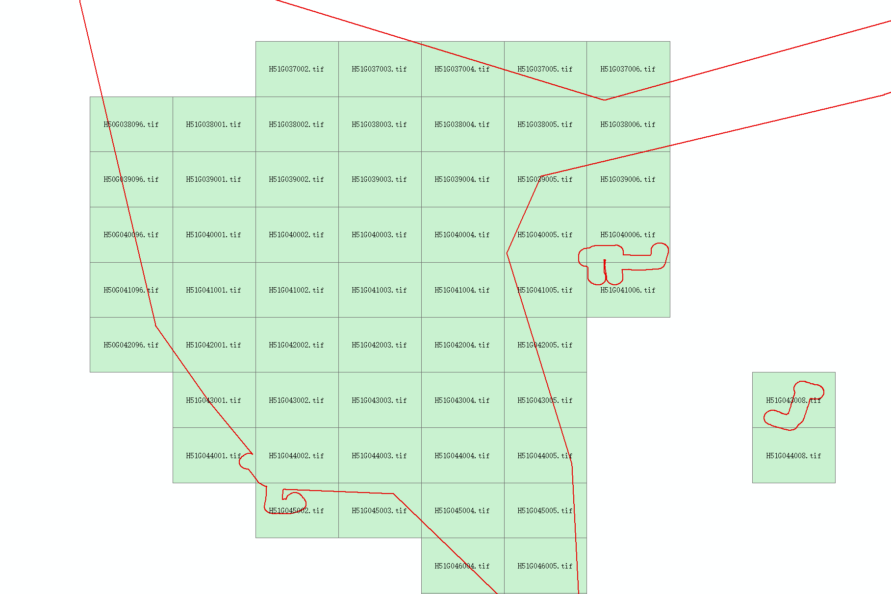
Detail showing alignment accuracy
Implementation Code
# -*- coding: utf-8 -*-
import os
import time
import arcpy

def create_directory(path):
    """Ensure directory exists, create if missing"""
    if os.path.isdir(path):
        if not os.path.exists(path):
            os.makedirs(path)
    else:
        parent_dir = os.path.dirname(path)
        if not os.path.exists(parent_dir):
            os.makedirs(parent_dir)

if __name__ == '__main__':
    # Configure input/output
    raster_directory = r'F:\gisData\data0929\refY202410072'
    output_shapefile = os.path.join(raster_directory, 'shp', 'RasterExtent.shp')

    start_time = time.time()
    arcpy.env.workspace = raster_directory
    raster_list = arcpy.ListRasters()

    if not raster_list:
        raise IOError("Error: No raster files found!")

    # Prepare output feature class
    if arcpy.Exists(output_shapefile):
        arcpy.Delete_management(output_shapefile)

    create_directory(output_shapefile)
    output_fc = arcpy.CreateFeatureclass_management(
        os.path.dirname(output_shapefile),
        "RasterExtent.shp",
        "POLYGON"
    )
    arcpy.AddField_management(output_fc, "RasterName", "TEXT", 50)

    # Process rasters
    with arcpy.da.InsertCursor(output_fc, ["SHAPE@", "RasterName"]) as cursor:
        for raster_file in raster_list:
            raster = arcpy.Raster(raster_file)
            extent = raster.extent

            # Construct polygon from extent
            polygon_points = arcpy.Array([
                arcpy.Point(extent.XMin, extent.YMin),  # LL
                arcpy.Point(extent.XMin, extent.YMax),  # UL
                arcpy.Point(extent.XMax, extent.YMax),  # UR
                arcpy.Point(extent.XMax, extent.YMin),  # LR
                arcpy.Point(extent.XMin, extent.YMin)   # Close ring
            ])

            cursor.insertRow([arcpy.Polygon(polygon_points), raster_file])

    # Performance metrics
    elapsed = time.time() - start_time
    print(f"Process completed in: {elapsed:.2f} seconds")
Key Workflow
- Input Configuration: Specify directory containing raster files
- Output Handling: Automatically creates output shapefile
Extent Extraction:
- Retrieves XMin/YMin/XMax/YMax for each raster
- Constructs rectangular polygons from corner coordinates
- Attribute Storage: Preserves original raster filenames
Advantages
- Eliminates manual extent digitization
- Enables efficient coverage gap analysis
- Handles thousands of rasters in batch processing
- Integrates with standard ArcGIS workflows
Note: Requires ArcGIS Desktop with Spatial Analyst extension. Execution time scales linearly with raster count.