MalaGIS

Sharing GIS Technologies, Resources and News.

A GIS Valentine: Bonne Projection and Drawing from the Heart

Valentine’s Day is here again, and the GIS community group at Malagis is buzzing with excitement. Watching the lively discussions makes one nostalgic for youthful enthusiasm. On such a romantic day, shouldn't everything—including GIS—have its own charm? Let’s explore two GIS-inspired romantic ideas shared by the group.

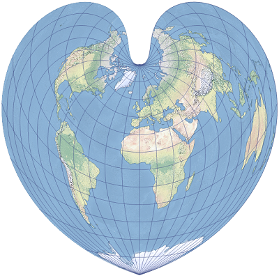
1. The Bonne Projection

Do you still remember the Bonne projection? Or have your cartography lessons faded into memory? Here's what it looks like:

more >>

Generating Provincial Capital Point Layers in QGIS Using DeepSeek AI

When visualizing national highway mileage across Chinese provinces in QGIS, I needed provincial capital markers without local data access. Using DeepSeek AI, I generated geographic layers directly in QGIS via Python scripting.


Visualization requiring provincial capitals

more >>

Georeferencing Marathon Route Maps in QGIS: Manual vs. AI-Assisted Approaches

When crafting dynamic marathon routes from official maps, directly tracing simplified route images is inefficient without proper spatial referencing. Georeferencing solves this by aligning raster images with real-world coordinates.

more >>

Using AI to Automatically Vectorize in QGIS: A Practical Guide

With the rapid development of AI technologies—such as in our earlier article A First Look at Using Segment Anything for GIS and the booming trend of generative AI—many GIS professionals might wonder: is there an AI tool that can help with vectorization tasks? The answer is yes. In this article, we will explore how to use an AI-powered plugin in QGIS to automate vectorization.

more >>

Copyright © 2020-2026 MalaGIS Drive by Typecho & Lingonberry Sitemap

Back to top