MalaGIS

Sharing GIS Technologies, Resources and News.

Installing Third-Party Libraries for ArcGIS Desktop Python Environment

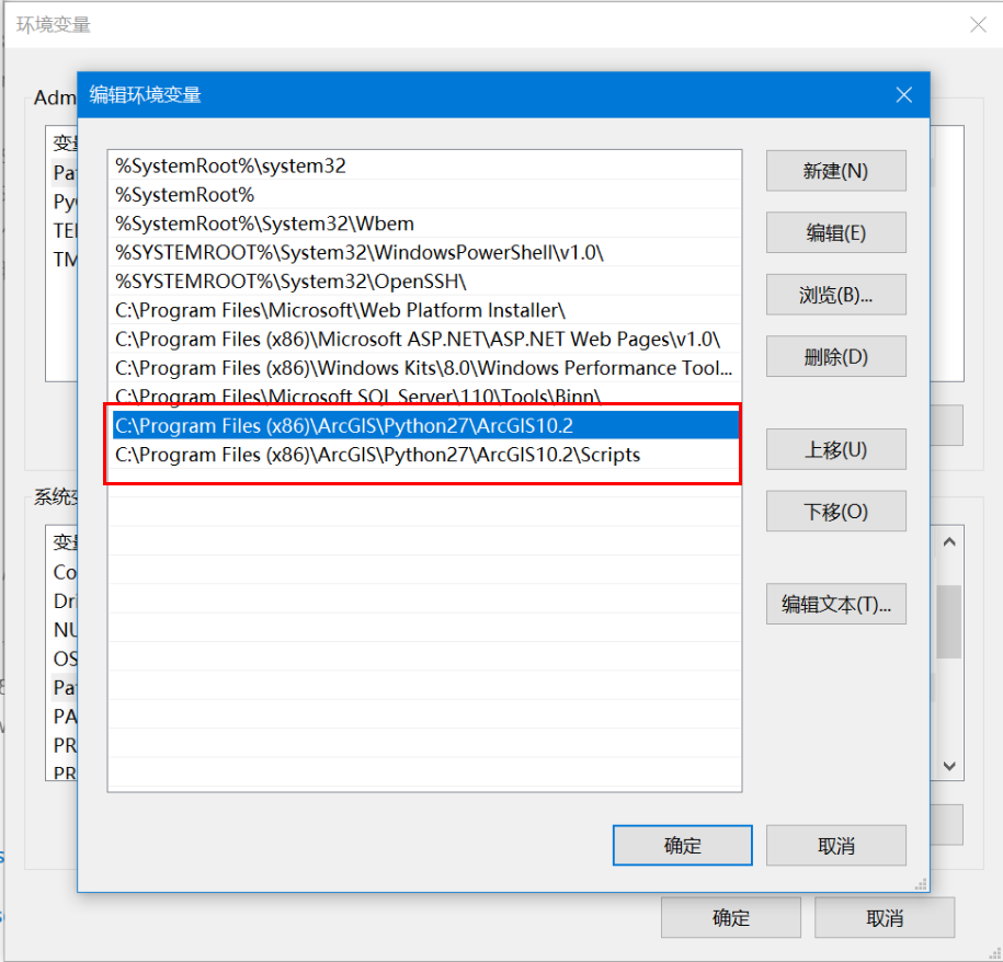
When working on data processing projects with ArcGIS Desktop (non-Pro version), extending arcpy functionality often requires installing third-party libraries. Since Python 2 doesn't include pip by default, this guide outlines the installation process.

Prerequisites

  1. Install ArcGIS Desktop
  2. Add Python path to environment variables (e.g., C:\Python27\ArcGIS10.X)
  3. Remove other Python paths from system variables

more >>

Python for Data Analysis (3rd Edition): Comprehensive Resource Package

We're sharing the third edition of the bestselling book Python for Data Analysis, including complete sample code repositories, PDF version, and online access links.

more >>

Installing Python Packages in ArcGIS Environments: Manual and Automated Approaches

When extending ArcGIS Python functionality (e.g., using openpyxl for Excel integration), installing supplementary packages becomes necessary. This guide demonstrates manual and automated installation methods for both online and offline scenarios.

more >>

Practical Python Integration in ArcGIS: Key Implementation Methods

Using Python within ArcGIS requires foundational Python knowledge. The following modules support Python integration:

more >>

Converting GIS Polygons to WKT Format with QGIS and Python

While developing a workflow involving spatial data duplication, an analyst requested help with client requirements:
① Convert individual polygons to WKT format in TXT files
② Merge multiple polygons into MultiPolygon WKT format

1713798782717

more >>

Python GDAL Tutorial: Raster Data Processing Essentials

This article summarizes common Python GDAL code snippets for geospatial data processing. GDAL (Geospatial Data Abstraction Library) is a foundational library for handling raster and vector geospatial data, maintained by the Open Source Geospatial Foundation (OSGeo). Implemented in C/C++, it provides Python, Java, and other language bindings. When calling GDAL's API in Python, the underlying execution relies on compiled C/C++ binaries.

GDAL Official Site: https://gdal.org/
Python API Documentation: https://gdal.org/api/index.html#python-api

more >>

Python Workflows for GIS Data Conversion: WKT, Shapefiles

During development of a grid management system, I initially planned to use PostgreSQL for storing grid WKT data (for direct SHP export and map service publishing). Due to incompatibility with backend framework requirements, I switched to MySQL. This necessitated converting MySQL-stored WKT to Shapefiles. The solution: Java scheduled tasks invoking Python scripts to automate conversion. Below are the code implementations.

1. WKT to Shapefile Conversion

Preview:

more >>

Copyright © 2020-2025 MalaGIS Drive by Typecho & Lingonberry Sitemap

Back to top