MalaGIS

Sharing GIS Technologies, Resources and News.

Integrating Tianditu Basemaps in ArcMap: Step-by-Step Guide

Author: An anonymous GIS professional specializing in astronomy, geography, remote sensing, and geomancy.

Tianditu (National Platform for Common Geospatial Information Services), hosted by the Ministry of Natural Resources, provides public online geospatial services and promotes geospatial data sharing. For GIS professionals, a common requirement is loading various online basemaps. Tianditu offers convenient services for desktop software like ArcMap and QGIS. While QGIS has mature plugins, this guide focuses on ArcMap users.

more >>

Global Continent Boundary Datasets: A Comparative Analysis

Following my previous article "GIS Data: Global Time Zone Boundary Data (SHP Format)", several readers requested global continent boundary datasets. Surprisingly, this data proved readily available. Below is a comparative overview of three authoritative sources.

Data Preview:

more >>

Practical Application of Geo Hound: Extracting Wuhan's Unified Planning Map Services for GIS Analysis

Geo Hound is a browser extension that automatically captures map service links from web pages and centralizes their management. In a previous article, I introduced this tool using a Japanese map service example. To demonstrate its practical value, I'll showcase its application with Wuhan's Unified Planning Map.

Wuhan Unified Planning Map

This platform integrates legally approved regulatory plans, including:

  • Detailed Control Plans for Wuhan Main Urban Area (65 zones)
  • New Town Group Control Plans (155 zones)
  • East Lake Scenic Area Master Plan
  • Municipal infrastructure corridor plans

Managed by Wuhan Planning Bureau, it dynamically updates per national/local regulations.

Access:
http://whonemap.zrzyhgh.wuhan.gov.cn:8020/
(Note: The site uses HTTP instead of HTTPS)

more >>

ArcGIS Desktop in 2025: Why This Veteran GIS Platform Endures

A reader recently noted that my earlier guide on purchasing licensed ArcGIS Pro is outdated. Upon review, I confirmed this—Esri no longer offers ArcGIS Desktop 10.8.2 for personal purchase, leaving only ArcGIS Pro available. Essentially, individual users can no longer legally acquire Desktop versions.

more >>

Installing Third-Party Libraries for ArcGIS Desktop Python Environment

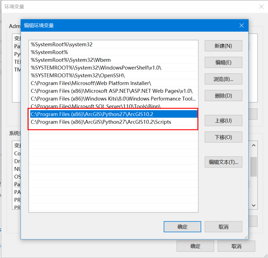
When working on data processing projects with ArcGIS Desktop (non-Pro version), extending arcpy functionality often requires installing third-party libraries. Since Python 2 doesn't include pip by default, this guide outlines the installation process.

Prerequisites

  1. Install ArcGIS Desktop
  2. Add Python path to environment variables (e.g., C:\Python27\ArcGIS10.X)
  3. Remove other Python paths from system variables

more >>

Global Forest Age Dataset (GAMI): 100m Resolution Mapping

We're introducing the Global Age Mapping Integration (GAMI) dataset—a high-resolution global forest age distribution resource for 2010 and 2020.

more >>

ArcGIS Pro Configuration Reset Tool: Resolving Common Application Issues

Following our previous article 《https://malagis.com/arcgis-pro-3-1-6-installation-problem-solution.html》, we're sharing a community-developed utility that addresses persistent application anomalies. This tool efficiently resets user configurations to resolve multiple operational failures.

more >>

Installing Python Packages in ArcGIS Environments: Manual and Automated Approaches

When extending ArcGIS Python functionality (e.g., using openpyxl for Excel integration), installing supplementary packages becomes necessary. This guide demonstrates manual and automated installation methods for both online and offline scenarios.

more >>

Practical Python Integration in ArcGIS: Key Implementation Methods

Using Python within ArcGIS requires foundational Python knowledge. The following modules support Python integration:

more >>

Global Soil Erodibility Dataset (2023 Edition)

We're sharing a valuable 2023 global soil erodibility dataset acquired through complex application procedures. This resource is particularly useful for GIS researchers conducting soil erosion studies.

more >>

Copyright © 2020-2025 MalaGIS Drive by Typecho & Lingonberry Sitemap

Back to top